WATERFRONToronto
November 6, 2018 Via Email
RE: Port Lands Flood Protection & Enabling Infrastructure – Cherry Street North Bridge
We are writing to provide information and an update on a project that may be of interest to your organization, the Port Lands Flood Protection & Enabling Infrastructure (PLFPEI) Project.
Project Description
PLFPEI is a comprehensive plan for protecting southeastern portions of downtown Toronto from flooding in the event of a provincially defined Regulatory Storm. This includes parts of the Port Lands, South Riverdale, Leslieville, south of Eastern Avenue and the First Gulf/Unilever development site.
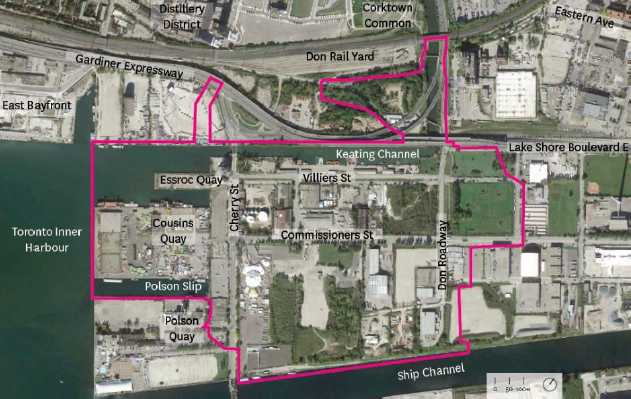 [Figure 1 - Project Area: Existing Conditions. Project area outlined in pink.]
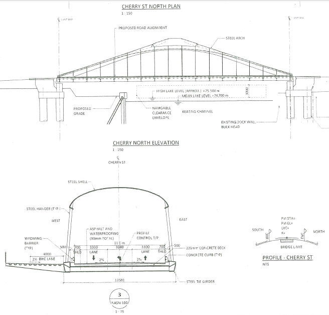
Cherry Street Bridge Demolition and Construction A key part of the PLFPEI Project is the removal and replacement of the existing Cherry Street Bridge. The new Cherry Street North Bridge will span the Keating Channel and will be located along a realigned new Cherry Street, approximately 120 meters west of the existing Cherry Street.
The new Cherry Street North Bridge plays a critical role in achieving flood protection. During a major storm, the existing Cherry Street Bridge and abutments (particularly the south abutment) create a pinch point in the Keating Channel, contributing to flooding. Removing the existing bridge and abutments will allow us to widen the channel at this location and improve flood conveyance during large flood events. To maintain access in and out of the Port Lands west of the Don River, the new Cherry Street North Bridge will be constructed prior to the removal of the existing Cherry Street Bridge. Construction is expected to begin in January 2019. Additional information can be found through the links provided below.
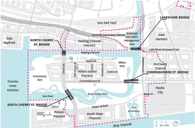
[Figure 2 - PLFPEI Proposed Bridges]
Background and Context
Providing flood protection for the Port Lands was identified as a top priority by all three levels of government when they first established Waterfront Toronto in 2001. Working together over the past decade, Waterfront Toronto, Toronto and Region Conservation Authority (TRCA), the City of Toronto and the Toronto Port Lands Company (now CreateTO) have developed and refined a solution to naturalize the mouth of the Don River and protect the Port Lands and nearby neighbourhoods from potential flooding. The PLFPEI Project will create a new mouth for the Don River in the middle of the Port Lands between the ship channel and the Keating Channel.
Naturalizing the mouth of the Don River will provide the necessary flood protection and unlock the development potential of this waterfront area. A new urban island neighbourhood called Villiers Island will emerge on the south side of Keating Channel. In addition, the project will also enhance habitat for natural species and will re-establish river and wetland habitat in the area, which provide social and environmental benefits and naturally moderate the effects of flooding and erosion.
The PLFPEI Project has been informed by extensive engagement and consultation with the public, government agencies, stakeholders, Indigenous communities, and landowners and developers. It is consistent with the City of Toronto’s primary waterfront planning document, the Central Waterfront Secondary Plan. It also secured key environmental assessment approvals in 2014 from the Ministry of the Environment, Conservation and Parks (formerly the Ministry of the Environment and Climate Change):
• Lower Don Lands Master Plan Class Environmental Assessment; and
• Don Mouth Naturalization and Port Lands Flood Protection Project Environmental Assessment.
Navigation Protection Act
The Navigation Protection Act authorizes and regulates the public’s right to unobstructed passage over navigable waters. The process evaluates potential impacts to navigation and acts to minimize those impacts. An undertaking in, on, over, through or across any navigable water in Canada triggers this process. As part of the approval process for the Cherry Street North Bridge project, Waterfront Toronto is required to submit a Notice of Works form pursuant to the Navigation Protection Act.
The Navigation Protection Act authorizes and regulates the public’s right to unobstructed passage over navigable waters. The process evaluates potential impacts to navigation and acts to minimize those impacts. An undertaking in, on, over, through or across any navigable water in Canada triggers this process. As part of the approval process for the Cherry Street North Bridge project, Waterfront Toronto is required to submit a Notice of Works form pursuant to the Navigation Protection Act.
Navigation was a topic covered in both the Lower Don Lands Master Plan Class Environmental Assessment and Don Mouth Naturalization and Port Lands Flood Protection Project Environmental Assessment. The Don Mouth Naturalization and Port Lands Flood Protection Project Environmental Assessment conducted a Navigation Risk Report and Updated Maneuvering Circle Assessment. This report identified and assessed navigation risks and proposed mitigation measures. The report can be found here: http://www.trca.on.ca/dotAsset/182028.pdf. Navigation was a topic covered as part of the Environmental Assessment consultation program. A summary of the consultation record can be found here: http://www.trca.on.ca/dotAsset/181980.pdf.
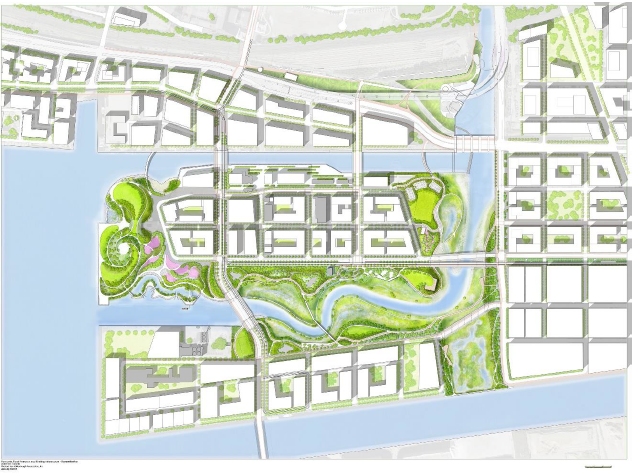 [Figure 3 - Aerial View of Proposed Full Vision for the Port Lands, including a new river valley and naturalized mouth for the Don River.]
Stakeholder Engagement
The proposed design for the new Cherry Street North Bridge is attached to this document. This bridge will be fixed and will replace the existing lift bridge. The elevation of the underside of the bridge will be 79.45 m CGS 1928. During high lake level (El. 75.50 m CGS 1928), the navigation clearance will be 3.0 metres plus 0.95 m buffer; during mean lake level (El. 74.70 m CGS 1928), the clearance will be 3.8 metres plus 0.95 m buffer. For more information, refer to drawings NASN-100 and NAAC-100 attached herein. Please provide comments regarding the effect of the vertical clearance change on marine navigation directly to Transport Canada at:
The Manager, Navigation Protection Program
Transport Canada
100 Front Street South,
Sarnia, ON N7T 2M4
Or via Email at:
NPPONT-PPNONT@tc.gc.ca
Comments will be considered only if they are in writing and are received not later than 60 days after the date of this letter. Although all comments will be considered, no individual response will be sent.
We will continue to keep you updated on the PLFPEI project as we move forward with the design.
Best Regards,
Simon Karam
Project Director
20 Bay Street, Suite 1310
Toronto, ON
M5J 2N8
Tel: 416.214.1344
Fax: 416.214.4591
www.waterfrontoronto.ca
Information Links:
Community Consultation, July 22, 2018 – Presentation Material (PDF)
PLFPEI Project Components
Cherry Street Stormwater and Lakefilling Project (PDF)
Waterfront Toronto Release Due Diligence Report on Port Lands Flood Protection Enabling Infrastructure (PLFPEI), October 20, 2016
Don Mouth Naturalization and Port Lands Flood Protection Project Environmental Assessment
Lower Don Lands Master Plan Class Environmental Assessment